| This post may contain affiliate links. If you click on the links and buy, we get a commission. It doesn’t cost you anything. See the full disclaimer here. |
During the late 19th century, the population of Los Angeles exploded from 5,000 to 100,000 in just 30 years. In 1870, Los Angeles was a settlement of 5000 villagers. But by 1900, the population was 100,000. And there’s no better way to see this than with old maps of Los Angeles.
These 18 authentic old maps of Los Angeles show just how crazy the city grown has been in just 150 years.
The maps are high resolution, carefully curated and wonderfully hand drawn in 3D, with delicate attention to detail. They show LA from 1870 to the 1940s.
The camera pans around, showing the incredible detail of the work and skill of the artist.
These maps are also available to buy as large high-resolution prints, shipped to you.
We’re so inspired by the maps that we made a video tour of them. Check it out!
Los Angeles – The Sprawling Giant
Today, the City of Los Angeles has a population of 3.9 million, with the Los Angeles County totaling 10 million. The greater Los Angeles Five-County Area is home to a staggering 18.6 million people.
Los Angeles metropolitan area has seen massive growth over the past hundred years. Even in the 1920s, it was already an emerging powerhouse, with a population around 500,000.
Today, the largest city in California is home to over 10 million people and is one of the most diverse and exciting cities in America. LA history is rich, dating back to the days of the Wild West. In 100 years, its population has increased 20 times in size. The scale of development of the city has been astounding.
LA truly was the Wild West
The area was first settled by Spanish settlers in 1781 and quickly became a booming center for trade, commerce, and entertainment. During the early 19th century, Los Angeles was an untamed land of Native Americans, fur trappers, ranchers and miners. They all competed for resources like water and grazing lands, which made for a dangerous situation that often led to violence.

That was the “Cowboy Wars,” when shootouts were common on the streets of Los Angeles. Eventually, the Wild West gave way to order. Today, Los Angeles continues to be a vibrant city with its Wild West roots still visible in its architecture and culture.
3D Aerial Maps of Los Angeles
The maps are hand drawn in 3D from a bird’s-eye aerial perspective. 3D aerial images are not to scale, given that they have depth and perspective. But the maps give the reader a visual reference and an understanding of the geographic area.
3D aerial maps of Los Angeles are an incredible way to look at terrain. A bird’s-eye view of the city with its many landmarks, streets, residential neighborhoods and other points of interest. They are all detailed high resolution 3D images and you can zoom in to get a closer look at any area.
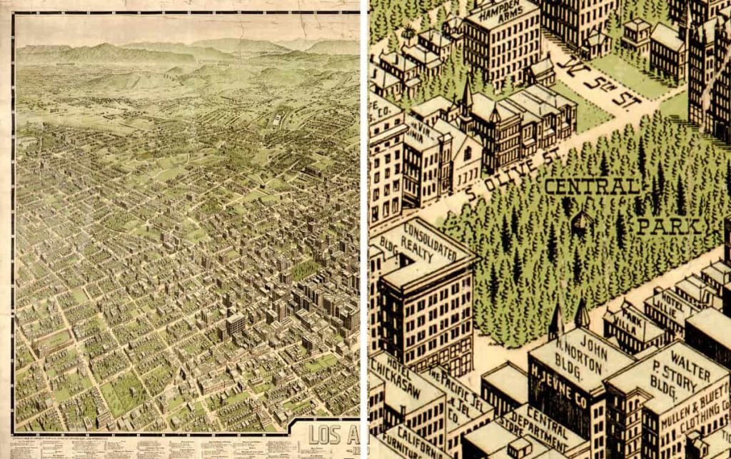
With these maps, you can also see exactly how far away certain points are from one another, making it easier to appreciate the city. The artists have labelled them with other annotations to help identify areas or buildings easily. 3D aerial maps of Los Angeles are perfect for anyone wanting to explore the city,
They feature landmarks, streets, and neighborhoods in stunning detail. The artists created these maps with love and attention to detail, using archival quality materials that will last a lifetime.
What Areas of Los Angeles are there?
They show many of the oldest parts of Los Angeles, from Downtown to Hollywood, Pasadena to Santa Barbara. They show the oldest parts of Los Angeles to the oil fields, Olvera Street, historical sites and celebrities. See Southern California, Long Beach and the coast. See locations like the university, Catalina Island and Los Angeles county.
You can directly compare the development of the land from farming, through small settlements to the built-up city it is today.
The second largest city in the United States has always seen rapid development. Since the 1900s, it has been a never-ending task to build and provide its residents with everything they need. Today, some of the gold rush mania has slowed a little, but it continues to grow. It’s no wonder Los Angeles is one of the most innovative and exciting cities in America.
But back then, LA was a relatively unknown city – and it’s amazing to see how it has grown into one of the most popular destinations in America.
- Explore U.S. history with this captivating guide to the Wild West.
- Billy the Kid, Buffalo Bill, Seth Bullock, Davy Crockett, Annie Oakley, Jesse James, and Geronimo
- Eight captivating manuscripts in one book
- Quick read and a wonderful guide to American West History
How do I buy historical maps of Los Angeles?
Check out the links below to retailers that sell prints of these fine maps.
Which Maps are in the video?
Here’s the collection of maps in the video:
Map of Los Angeles 1871
Map of Santa Monica 1877
Map of Santa Catalina 1948
Map of Wilmington 1877
Map of San Pedro 1905
Map of Los Angeles 1877
Map of Pomona 1886
Map of Azusa 1887
Map of Brooklyn Heights 1891
Map of Los Angeles 1894
Map of Santa Barbara 1898
Map of Pasadena 1903
Map of Los Angeles 1909
Oil Fields of Los Angeles 1922
Los Angeles Wonder City 1932
Edison Electrical Map 1935
Los Angeles 1894 Looking South

How do I download historical maps of Los Angeles?
You can find and download digital versions of the maps at the Library of Congress Maps Collection. Most local libraries and archives should also have a cartographic collection.
We love hearing from you
What did you think of our latest video? Let us know in the comments below!


